


château de castelneau

JMJ42
User
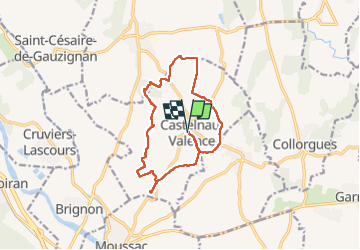

Length
13.7 km

Max alt
171 m

Uphill gradient
224 m
Km-Effort
16.7 km

Min alt
103 m

Downhill gradient
224 m
Boucle
Yes
Creation date :
2024-10-22 07:43:40.62
Updated on :
2024-10-22 12:51:14.438
3h33
Difficulty : Medium

FREE GPS app for hiking
 SityTrail
IGN / Geographical institutes
SityTrail Plus
The world is yours!
About
Trail Walking of 13.7 km to be discovered at Occitania, Gard, Castelnau-Valence. This trail is proposed by JMJ42.
Photos


Positioning
Country:
France
Region :
Occitania
Department/Province :
Gard
Municipality :
Castelnau-Valence
Location:
Unknown
Start:(Dec)
Start:(UTM)
600260 ; 4873529 (31T) N.
Comments