


les borrel3

bopapa
User
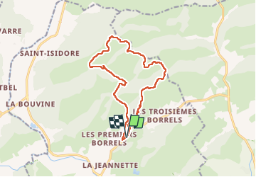

Length
14.6 km

Max alt
294 m

Uphill gradient
331 m
Km-Effort
19 km

Min alt
32 m

Downhill gradient
331 m
Boucle
Yes
Creation date :
2024-10-22 06:53:04.472
Updated on :
2024-10-22 12:56:43.833
5h15
Difficulty : Very difficult

FREE GPS app for hiking
 SityTrail
IGN / Geographical institutes
SityTrail Plus
The world is yours!
About
Trail Walking of 14.6 km to be discovered at Provence-Alpes-Côte d'Azur, Var, Hyères. This trail is proposed by bopapa.
Photos

Positioning
Country:
France
Region :
Provence-Alpes-Côte d'Azur
Department/Province :
Var
Municipality :
Hyères
Location:
Unknown
Start:(Dec)
Start:(UTM)
269633 ; 4782260 (32T) N.
Comments