


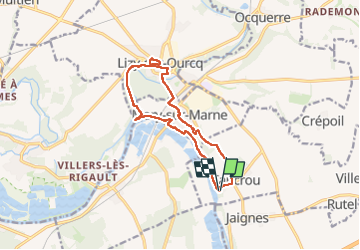
Tancrou du 22/10/2024

VANDERPUTTENMi
User GUIDE

Length
12 km

Max alt
101 m

Uphill gradient
133 m
Km-Effort
13.8 km

Min alt
45 m

Downhill gradient
133 m
Boucle
Yes
Creation date :
2024-10-22 08:42:25.594
Updated on :
2024-10-22 16:04:39.452
3h07
Difficulty : Difficult

FREE GPS app for hiking
 SityTrail
IGN / Geographical institutes
SityTrail Plus
The world is yours!
About
Trail Walking of 12 km to be discovered at Ile-de-France, Seine-et-Marne, Tancrou. This trail is proposed by VANDERPUTTENMi.
Photos


Positioning
Country:
France
Region :
Ile-de-France
Department/Province :
Seine-et-Marne
Municipality :
Tancrou
Location:
Unknown
Start:(Dec)
Start:(UTM)
503099 ; 5427282 (31U) N.
Comments