


2210

maxEA65
User
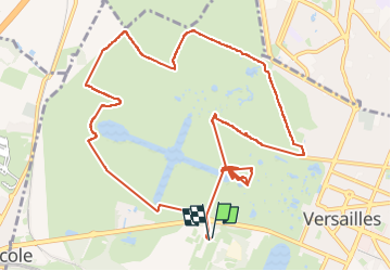

Length
13.1 km

Max alt
135 m

Uphill gradient
115 m
Km-Effort
14.6 km

Min alt
106 m

Downhill gradient
115 m
Boucle
Yes
Creation date :
2024-10-23 07:01:37.684
Updated on :
2024-10-23 09:50:37.93
2h47
Difficulty : Difficult

FREE GPS app for hiking
 SityTrail
IGN / Geographical institutes
SityTrail Plus
The world is yours!
About
Trail Walking of 13.1 km to be discovered at Ile-de-France, Yvelines, Versailles. This trail is proposed by maxEA65.
Positioning
Country:
France
Region :
Ile-de-France
Department/Province :
Yvelines
Municipality :
Versailles
Location:
Unknown
Start:(Dec)
Start:(UTM)
434353 ; 5405777 (31U) N.
Comments