


calanque

chrispaquet
User
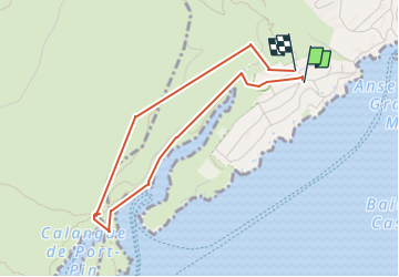

Length
4 km

Max alt
97 m

Uphill gradient
131 m
Km-Effort
5.8 km

Min alt
5 m

Downhill gradient
125 m
Boucle
Yes
Creation date :
2024-10-23 07:57:52.626
Updated on :
2024-10-23 11:35:58.913
3h37
Difficulty : Easy

FREE GPS app for hiking
 SityTrail
IGN / Geographical institutes
SityTrail Plus
The world is yours!
About
Trail Walking of 4 km to be discovered at Provence-Alpes-Côte d'Azur, Bouches-du-Rhône, Cassis. This trail is proposed by chrispaquet.
Positioning
Country:
France
Region :
Provence-Alpes-Côte d'Azur
Department/Province :
Bouches-du-Rhône
Municipality :
Cassis
Location:
Unknown
Start:(Dec)
Start:(UTM)
705247 ; 4787416 (31T) N.
Comments