


Pic de l'Ours

taguette
User
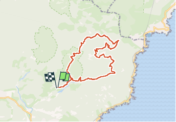

Length
17.6 km

Max alt
486 m

Uphill gradient
538 m
Km-Effort
25 km

Min alt
27 m

Downhill gradient
538 m
Boucle
Yes
Creation date :
2024-10-23 06:59:48.596
Updated on :
2024-10-23 13:26:09.336
5h42
Difficulty : Difficult

FREE GPS app for hiking
 SityTrail
IGN / Geographical institutes
SityTrail Plus
The world is yours!
About
Trail Walking of 17.6 km to be discovered at Provence-Alpes-Côte d'Azur, Var, Saint-Raphaël. This trail is proposed by taguette.
Positioning
Country:
France
Region :
Provence-Alpes-Côte d'Azur
Department/Province :
Var
Municipality :
Saint-Raphaël
Location:
Unknown
Start:(Dec)
Start:(UTM)
327613 ; 4813730 (32T) N.
Comments