


Éclans-Nenon

cmike39
User
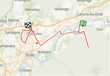

Length
41 km

Max alt
345 m

Uphill gradient
570 m
Km-Effort
49 km

Min alt
200 m

Downhill gradient
520 m
Boucle
No
Creation date :
2024-10-22 06:54:16.879
Updated on :
2024-10-23 15:29:12.925
32h31
Difficulty : Very difficult

FREE GPS app for hiking
 SityTrail
IGN / Geographical institutes
SityTrail Plus
The world is yours!
About
Trail Walking of 41 km to be discovered at Bourgogne-Franche-Comté, Jura, Éclans-Nenon. This trail is proposed by cmike39.
Description
MN & Mont Roland 20241023
Positioning
Country:
France
Region :
Bourgogne-Franche-Comté
Department/Province :
Jura
Municipality :
Éclans-Nenon
Location:
Unknown
Start:(Dec)
Start:(UTM)
697414 ; 5222852 (31T) N.
Comments