


laon

olivieraron
User
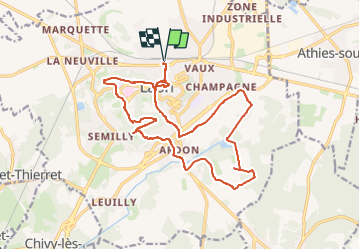

Length
18 km

Max alt
188 m

Uphill gradient
300 m
Km-Effort
22 km

Min alt
64 m

Downhill gradient
300 m
Boucle
Yes
Creation date :
2024-10-24 05:25:27.154
Updated on :
2024-10-24 05:54:55.725
4h59
Difficulty : Very difficult

FREE GPS app for hiking
 SityTrail
IGN / Geographical institutes
SityTrail Plus
The world is yours!
About
Trail Walking of 18 km to be discovered at Hauts-de-France, Aisne, Laon. This trail is proposed by olivieraron.
Positioning
Country:
France
Region :
Hauts-de-France
Department/Province :
Aisne
Municipality :
Laon
Location:
Unknown
Start:(Dec)
Start:(UTM)
545070 ; 5491049 (31U) N.
Comments