


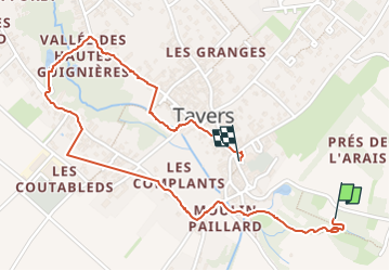
Tavers_circuit des eaux bleues

gdela
User

Length
2.8 km

Max alt
98 m

Uphill gradient
30 m
Km-Effort
3.2 km

Min alt
81 m

Downhill gradient
26 m
Boucle
Yes
Creation date :
2024-10-24 08:20:17.49
Updated on :
2024-10-25 15:27:18.642
43m
Difficulty : Easy

FREE GPS app for hiking
 SityTrail
IGN / Geographical institutes
SityTrail Plus
The world is yours!
About
Trail Walking of 2.8 km to be discovered at Centre-Loire Valley, Loiret, Tavers. This trail is proposed by gdela.
Positioning
Country:
France
Region :
Centre-Loire Valley
Department/Province :
Loiret
Municipality :
Tavers
Location:
Unknown
Start:(Dec)
Start:(UTM)
396197 ; 5290190 (31T) N.
Comments