


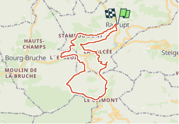
Climont par Ranrupt

LUTZMarc
User

Length
17.6 km

Max alt
714 m

Uphill gradient
578 m
Km-Effort
25 km

Min alt
509 m

Downhill gradient
578 m
Boucle
Yes
Creation date :
2024-10-24 07:01:20.647
Updated on :
2024-11-01 07:13:21.948
4h58
Difficulty : Medium

FREE GPS app for hiking
 SityTrail
IGN / Geographical institutes
SityTrail Plus
The world is yours!
About
Trail Walking of 17.6 km to be discovered at Grand Est, Bas-Rhin, Ranrupt. This trail is proposed by LUTZMarc.
Description
Resto à l’auberge des Cimes
Quelques montées exigences.
Positioning
Country:
France
Region :
Grand Est
Department/Province :
Bas-Rhin
Municipality :
Ranrupt
Location:
Unknown
Start:(Dec)
Start:(UTM)
366628 ; 5359429 (32U) N.
Comments