


Gonfaron Renée Cora

bernir
User
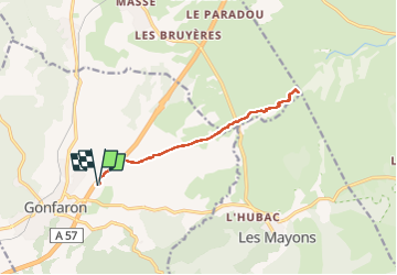

Length
12.7 km

Max alt
143 m

Uphill gradient
75 m
Km-Effort
13.7 km

Min alt
84 m

Downhill gradient
75 m
Boucle
Yes
Creation date :
2024-10-24 08:49:48.545
Updated on :
2024-10-29 18:32:35.509
3h07
Difficulty : Easy

FREE GPS app for hiking
 SityTrail
IGN / Geographical institutes
SityTrail Plus
The world is yours!
About
Trail Walking of 12.7 km to be discovered at Provence-Alpes-Côte d'Azur, Var, Gonfaron. This trail is proposed by bernir.
Positioning
Country:
France
Region :
Provence-Alpes-Côte d'Azur
Department/Province :
Var
Municipality :
Gonfaron
Location:
Unknown
Start:(Dec)
Start:(UTM)
281359 ; 4800438 (32T) N.
Comments