


La Ciotat le sémaphore

Yot
User
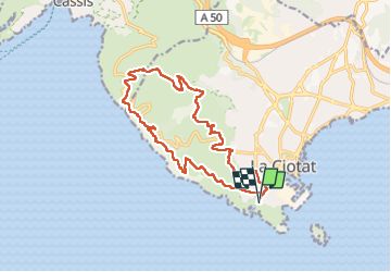

Length
17 km

Max alt
380 m

Uphill gradient
659 m
Km-Effort
26 km

Min alt
30 m

Downhill gradient
659 m
Boucle
Yes
Creation date :
2024-10-24 07:06:58.577
Updated on :
2024-10-24 14:53:24.073
5h12
Difficulty : Medium

FREE GPS app for hiking
 SityTrail
IGN / Geographical institutes
SityTrail Plus
The world is yours!
About
Trail Walking of 17 km to be discovered at Provence-Alpes-Côte d'Azur, Bouches-du-Rhône, La Ciotat. This trail is proposed by Yot.
Photos


Positioning
Country:
France
Region :
Provence-Alpes-Côte d'Azur
Department/Province :
Bouches-du-Rhône
Municipality :
La Ciotat
Location:
Unknown
Start:(Dec)
Start:(UTM)
711254 ; 4782687 (31T) N.
Comments