


port sainte Lucy Agay

taguette
User

Length
12.6 km

Max alt
97 m

Uphill gradient
208 m
Km-Effort
15.3 km

Min alt
0 m

Downhill gradient
199 m
Boucle
No
Creation date :
2024-10-25 07:19:00.731
Updated on :
2024-10-25 11:11:45.325
3h52
Difficulty : Difficult

FREE GPS app for hiking
 SityTrail
IGN / Geographical institutes
SityTrail Plus
The world is yours!
About
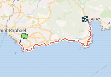
Trail Walking of 12.6 km to be discovered at Provence-Alpes-Côte d'Azur, Var, Saint-Raphaël. This trail is proposed by taguette.
Positioning
Country:
France
Region :
Provence-Alpes-Côte d'Azur
Department/Province :
Var
Municipality :
Saint-Raphaël
Location:
Unknown
Start:(Dec)
Start:(UTM)
320205 ; 4809321 (32T) N.
Comments