


Rochers de Naye - Caux

CIE NPS
User
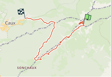

Length
8.1 km

Max alt
2009 m

Uphill gradient
88 m
Km-Effort
11.9 km

Min alt
1153 m

Downhill gradient
900 m
Boucle
No
Creation date :
2024-10-25 13:27:59.388
Updated on :
2024-10-25 13:38:49.905

FREE GPS app for hiking
 SityTrail
IGN / Geographical institutes
SityTrail Plus
The world is yours!
About
Trail of 8.1 km to be discovered at Vaud, District de la Riviera-Pays-d’Enhaut, Veytaux. This trail is proposed by CIE NPS.
Positioning
Country:
Switzerland
Region :
Vaud
Department/Province :
District de la Riviera-Pays-d’Enhaut
Municipality :
Veytaux
Location:
Unknown
Start:(Dec)
Start:(UTM)
344710 ; 5144019 (32T) N.
Comments