


18 Le Rocher des Monges par Maure-Vieil

clintest
User
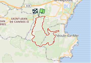

Length
17 km

Max alt
364 m

Uphill gradient
570 m
Km-Effort
25 km

Min alt
16 m

Downhill gradient
570 m
Boucle
Yes
Creation date :
2024-10-25 15:52:53.652
Updated on :
2024-10-25 15:52:53.652

FREE GPS app for hiking
 SityTrail
IGN / Geographical institutes
SityTrail Plus
The world is yours!
About
Trail of 17 km to be discovered at Provence-Alpes-Côte d'Azur, Maritime Alps, Mandelieu-la-Napoule. This trail is proposed by clintest.
Positioning
Country:
France
Region :
Provence-Alpes-Côte d'Azur
Department/Province :
Maritime Alps
Municipality :
Mandelieu-la-Napoule
Location:
Unknown
Start:(Dec)
Start:(UTM)
330489 ; 4821224 (32T) N.
Comments