


???

JorgV
User
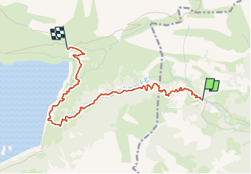

Length
3.6 km

Max alt
1980 m

Uphill gradient
450 m
Km-Effort
8.1 km

Min alt
1531 m

Downhill gradient
14 m
Boucle
No
Creation date :
2024-10-05 09:04:48.559
Updated on :
2024-10-26 10:01:38.356
1h25
Difficulty : Medium

FREE GPS app for hiking
 SityTrail
IGN / Geographical institutes
SityTrail Plus
The world is yours!
About
Trail Walking of 3.6 km to be discovered at Valais/Wallis, Saint-Maurice, Salvan. This trail is proposed by JorgV.
Positioning
Country:
Switzerland
Region :
Valais/Wallis
Department/Province :
Saint-Maurice
Municipality :
Salvan
Location:
Unknown
Start:(Dec)
Start:(UTM)
344489 ; 5111873 (32T) N.
Comments