


essai retour

Mickle Bertholon
User
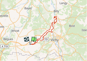

Length
56 km

Max alt
367 m

Uphill gradient
563 m
Km-Effort
63 km

Min alt
235 m

Downhill gradient
559 m
Boucle
Yes
Creation date :
2024-10-26 08:18:56.376
Updated on :
2024-10-26 10:53:07.579
2h01
Difficulty : Very easy

FREE GPS app for hiking
 SityTrail
IGN / Geographical institutes
SityTrail Plus
The world is yours!
About
Trail Quad of 56 km to be discovered at Auvergne-Rhône-Alpes, Allier, Cognat-Lyonne. This trail is proposed by Mickle Bertholon.
Positioning
Country:
France
Region :
Auvergne-Rhône-Alpes
Department/Province :
Allier
Municipality :
Cognat-Lyonne
Location:
Unknown
Start:(Dec)
Start:(UTM)
521910 ; 5105734 (31T) N.
Comments