


2024-10-27_13h50m47_83-cd-artignosc-le-chemin-de-l-eau

clintest
User
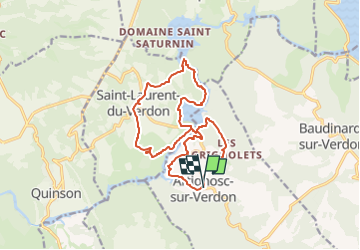

Length
16.9 km

Max alt
510 m

Uphill gradient
398 m
Km-Effort
22 km

Min alt
401 m

Downhill gradient
392 m
Boucle
Yes
Creation date :
2024-10-27 12:50:47.399
Updated on :
2024-10-27 12:50:48.618

FREE GPS app for hiking
 SityTrail
IGN / Geographical institutes
SityTrail Plus
The world is yours!
About
Trail of 16.9 km to be discovered at Provence-Alpes-Côte d'Azur, Var, Artignosc-sur-Verdon. This trail is proposed by clintest.
Description
Artignosc-Le Chemin de L'Eau
par J.J. le 11/09/2010
Positioning
Country:
France
Region :
Provence-Alpes-Côte d'Azur
Department/Province :
Var
Municipality :
Artignosc-sur-Verdon
Location:
Unknown
Start:(Dec)
Start:(UTM)
265543 ; 4843046 (32T) N.
Comments