


Ternay

potons
User
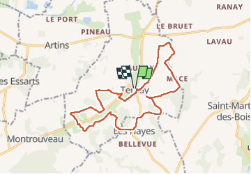

Length
16.4 km

Max alt
147 m

Uphill gradient
303 m
Km-Effort
20 km

Min alt
74 m

Downhill gradient
306 m
Boucle
Yes
Creation date :
2024-10-27 07:06:12.0
Updated on :
2024-10-27 13:17:48.314
3h20
Difficulty : Easy

FREE GPS app for hiking
 SityTrail
IGN / Geographical institutes
SityTrail Plus
The world is yours!
About
Trail Walking of 16.4 km to be discovered at Centre-Loire Valley, Loir-et-Cher, Ternay. This trail is proposed by potons.
Description
Sympa
Positioning
Country:
France
Region :
Centre-Loire Valley
Department/Province :
Loir-et-Cher
Municipality :
Ternay
Location:
Unknown
Start:(Dec)
Start:(UTM)
333381 ; 5288780 (31T) N.
Comments