


sylvanes fayet

lablaquiere
User
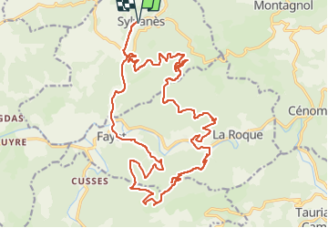

Length
28 km

Max alt
762 m

Uphill gradient
816 m
Km-Effort
39 km

Min alt
420 m

Downhill gradient
816 m
Boucle
Yes
Creation date :
2024-10-27 13:00:00.444
Updated on :
2024-10-27 16:04:42.398
2h16
Difficulty : Difficult

FREE GPS app for hiking
 SityTrail
IGN / Geographical institutes
SityTrail Plus
The world is yours!
About
Trail Mountain bike of 28 km to be discovered at Occitania, Aveyron, Sylvanès. This trail is proposed by lablaquiere.
Photos

Positioning
Country:
France
Region :
Occitania
Department/Province :
Aveyron
Municipality :
Sylvanès
Location:
Unknown
Start:(Dec)
Start:(UTM)
496685 ; 4853391 (31T) N.
Comments