


VTT

Alain Gasnot
User
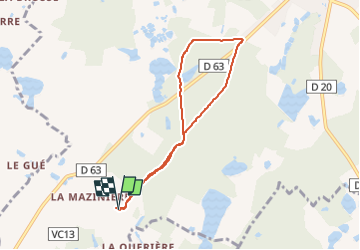

Length
6.8 km

Max alt
121 m

Uphill gradient
57 m
Km-Effort
7.5 km

Min alt
94 m

Downhill gradient
58 m
Boucle
Yes
Creation date :
2024-10-27 15:09:06.638
Updated on :
2024-10-27 16:29:32.586
1h19
Difficulty : Easy

FREE GPS app for hiking
 SityTrail
IGN / Geographical institutes
SityTrail Plus
The world is yours!
About
Trail Mountain bike of 6.8 km to be discovered at Centre-Loire Valley, Loir-et-Cher, Mur-de-Sologne. This trail is proposed by Alain Gasnot.
Positioning
Country:
France
Region :
Centre-Loire Valley
Department/Province :
Loir-et-Cher
Municipality :
Mur-de-Sologne
Location:
Unknown
Start:(Dec)
Start:(UTM)
392378 ; 5248986 (31T) N.
Comments