


Rompre

castorgris
User
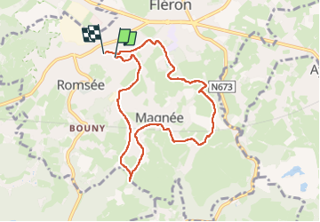

Length
7.5 km

Max alt
268 m

Uphill gradient
107 m
Km-Effort
8.9 km

Min alt
215 m

Downhill gradient
106 m
Boucle
Yes
Creation date :
2024-10-28 08:32:44.0
Updated on :
2024-10-28 11:03:51.951

FREE GPS app for hiking
 SityTrail
IGN / Geographical institutes
SityTrail Plus
The world is yours!
About
Trail of 7.5 km to be discovered at Wallonia, Liège, Fléron. This trail is proposed by castorgris.
Positioning
Country:
Belgium
Region :
Wallonia
Department/Province :
Liège
Municipality :
Fléron
Location:
Unknown
Start:(Dec)
Start:(UTM)
689080 ; 5609903 (31U) N.
Comments