


Lexy

patdecosnes
User
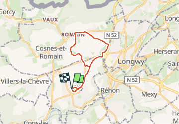

Length
9.8 km

Max alt
396 m

Uphill gradient
105 m
Km-Effort
11.2 km

Min alt
348 m

Downhill gradient
103 m
Boucle
Yes
Creation date :
2024-10-28 12:46:25.0
Updated on :
2024-10-28 15:31:44.276
2h33
Difficulty : Medium

FREE GPS app for hiking
 SityTrail
IGN / Geographical institutes
SityTrail Plus
The world is yours!
About
Trail Walking of 9.8 km to be discovered at Grand Est, Meurthe-et-Moselle, Lexy. This trail is proposed by patdecosnes.
Positioning
Country:
France
Region :
Grand Est
Department/Province :
Meurthe-et-Moselle
Municipality :
Lexy
Location:
Unknown
Start:(Dec)
Start:(UTM)
697445 ; 5486814 (31U) N.
Comments