


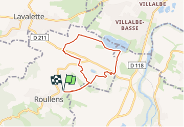
Roullens - Lac de taure

Combaut11
User

Length
6.6 km

Max alt
218 m

Uphill gradient
136 m
Km-Effort
8.4 km

Min alt
133 m

Downhill gradient
136 m
Boucle
Yes
Creation date :
2024-10-29 09:42:59.3
Updated on :
2024-10-29 09:45:31.875
1h55
Difficulty : Medium

FREE GPS app for hiking
 SityTrail
IGN / Geographical institutes
SityTrail Plus
The world is yours!
About
Trail Walking of 6.6 km to be discovered at Occitania, Aude, Roullens. This trail is proposed by Combaut11.
Description
Boucle au départ de Roullens - Lac de Taure - Montlaur
Positioning
Country:
France
Region :
Occitania
Department/Province :
Aude
Municipality :
Roullens
Location:
Unknown
Start:(Dec)
Start:(UTM)
441282 ; 4779571 (31T) N.
Comments