


Lalande en son, le fil

Marie-Claire-mcp
User
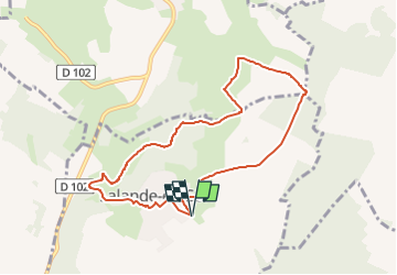

Length
7.9 km

Max alt
219 m

Uphill gradient
126 m
Km-Effort
9.6 km

Min alt
102 m

Downhill gradient
125 m
Boucle
Yes
Creation date :
2024-10-29 11:40:41.009
Updated on :
2024-10-30 12:12:39.751
2h10
Difficulty : Medium

FREE GPS app for hiking
 SityTrail
IGN / Geographical institutes
SityTrail Plus
The world is yours!
About
Trail Walking of 7.9 km to be discovered at Hauts-de-France, Oise, Lalande-en-Son. This trail is proposed by Marie-Claire-mcp.
Description
départ du parking de la rue des racines à côté du parc de jeux et stade
Positioning
Country:
France
Region :
Hauts-de-France
Department/Province :
Oise
Municipality :
Lalande-en-Son
Location:
Unknown
Start:(Dec)
Start:(UTM)
412007 ; 5471492 (31U) N.
Comments