


trompettes

claudesauzay
User

Length
3.6 km

Max alt
464 m

Uphill gradient
114 m
Km-Effort
5.1 km

Min alt
361 m

Downhill gradient
102 m
Boucle
No
Creation date :
2024-10-29 09:33:16.169
Updated on :
2024-10-29 11:41:20.635
2h07
Difficulty : Easy

FREE GPS app for hiking
 SityTrail
IGN / Geographical institutes
SityTrail Plus
The world is yours!
About
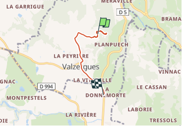
Trail Walking of 3.6 km to be discovered at Occitania, Aveyron, Valzergues. This trail is proposed by claudesauzay.
Description
champignons
Positioning
Country:
France
Region :
Occitania
Department/Province :
Aveyron
Municipality :
Valzergues
Location:
Unknown
Start:(Dec)
Start:(UTM)
438635 ; 4928404 (31T) N.
Comments