


CARREFOUR D'HARFONTAINE AR

surceneux
User
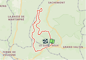

Length
15 km

Max alt
1025 m

Uphill gradient
469 m
Km-Effort
21 km

Min alt
783 m

Downhill gradient
470 m
Boucle
Yes
Creation date :
2024-10-29 07:40:46.973
Updated on :
2024-10-29 13:50:05.039
3h20
Difficulty : Medium

FREE GPS app for hiking
 SityTrail
IGN / Geographical institutes
SityTrail Plus
The world is yours!
About
Trail Walking of 15 km to be discovered at Grand Est, Vosges, Ban-sur-Meurthe-Clefcy. This trail is proposed by surceneux.
Description
SURCENEUX BASSE DE L'EAU CARREFOUR D'HARFONTAINE CHALET PREUX ROCHE DES CHIEN FONIE SURCENEUX
Positioning
Country:
France
Region :
Grand Est
Department/Province :
Vosges
Municipality :
Ban-sur-Meurthe-Clefcy
Location:
Unknown
Start:(Dec)
Start:(UTM)
347854 ; 5329047 (32U) N.
Comments