


benat ouest

bernir
User
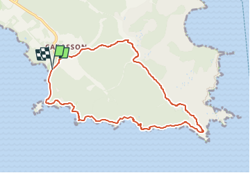

Length
9.6 km

Max alt
162 m

Uphill gradient
253 m
Km-Effort
13 km

Min alt
0 m

Downhill gradient
252 m
Boucle
Yes
Creation date :
2024-10-29 18:14:56.533
Updated on :
2024-10-30 13:08:19.559
2h57
Difficulty : Medium

FREE GPS app for hiking
 SityTrail
IGN / Geographical institutes
SityTrail Plus
The world is yours!
About
Trail Walking of 9.6 km to be discovered at Provence-Alpes-Côte d'Azur, Var, Bormes-les-Mimosas. This trail is proposed by bernir.
Positioning
Country:
France
Region :
Provence-Alpes-Côte d'Azur
Department/Province :
Var
Municipality :
Bormes-les-Mimosas
Location:
Unknown
Start:(Dec)
Start:(UTM)
282386 ; 4775415 (32T) N.
Comments