Trail Walking Grächen - YHH072 Grächen - Wannehorn - Photo

YHH072 Grächen - Wannehorn

© OpenStreetMap contributors
Length
Length
11.1 km
Max alt
Max alt
2648 m
Uphill gradient
Uphill gradient
616 m
Km-Effort
Km-Effort  
21 km
Min alt
Min alt
1733 m
Downhill gradient
Downhill gradient
1005 m
Boucle
Boucle
No
Creation date :
2014-12-10 00:00:00.0
Updated on :
2014-12-10 00:00:00.0

(0 Reviews)

Walking
Walking
6h00
Difficulty : Unknown

Scan this QR Code to open this trail in the SityTrail application

FREE GPS app for hiking

Logo SityTrail SityTrail

IGN / Geographical institutes

Download SityTrail from the App Store Download SityTrail from Google Play

Logo SityTrail SityTrail World

The world is yours!

Download SityTrail from the App Store Download SityTrail from Google Play Download SityTrail on Huawei AppGallery

About

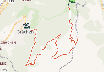
Trail Walking of 11.1 km to be discovered at Valais/Wallis, Visp, Grächen. This trail is proposed by yveshumbert.

Description

Pour éviter trop de dénivelé positif, la première partie se fait en télécabine jusqu'' à Hannigalp. On prend ensuite un joli chemin montant dans la forêt. Une fois hors de la forêt s'' est moins sympa on se retrouve sur les pistes de ski. On atteind rapidemment le sommet du Wannerhorn. On commence ensuite la descente à flanc de montagne en direction du Steetalhorn. Puis on oblique sur Stafel. Le retour se fait ensuite par un joli chemin dans la forêt. Il faudra à quelques reprises traverser des parmi des grosses pierres. Sur le retour vous pourrez vous arrêtez au restaurant au coté du lac zum See

Elevation profile

Positioning

Country:
Switzerland
Region :
Valais/Wallis
Department/Province :
Visp
Municipality :
Grächen
Location:
Unknown
Start:(UTM)
412675 ; 5117621 (32T) N.

Trails nearby

Trail On foot Grächen - Grächen-St. Niklaus - Photo
On foot
PRO

On foot

Easy
Grächen, Valais/Wallis, Visp, Switzerland
4.3 km | 6.2 km-effort
1h 23min
No
Trail On foot Grächen - Hannigalp-Saas-Fee - Photo
On foot
PRO

On foot

Medium
Grächen, Valais/Wallis, Visp, Switzerland
14.4 km | 25 km-effort
5h 39min
No
Trail Walking Grächen - Grächen et ses bisses 07.2018 - Photo
Walking
duamerg

Walking

Medium
Grächen, Valais/Wallis, Visp, Switzerland
14.1 km | 19.8 km-effort
4h 10min
Yes
Trail Other activity Staldenried - sf10_e11c - Photo
Other activity
GUIDE+

Other activity

Very easy
Staldenried, Valais/Wallis, Visp, Switzerland
19.3 km | 35 km-effort
8h 30min
No
Trail Walking Törbel - sf10_e11b - Photo
Walking
GUIDE+

Walking

Very easy
Törbel, Valais/Wallis, Visp, Switzerland
14.2 km | 30 km-effort
6h 36min
No
Trail Other activity Staldenried - y10_gspon_saas - Photo
Other activity
GUIDE+

Other activity

Very easy
Staldenried, Valais/Wallis, Visp, Switzerland
19.3 km | 33 km-effort
7h 50min
No
Trail Mountain bike Staldenried - Gspon - Photo
Mountain bike
GUIDE+

Mountain bike

Very easy
Staldenried, Valais/Wallis, Visp, Switzerland
22 km | 33 km-effort
7h 51min
No
Trail Walking Grächen - st_ny0914 - Photo
Walking
GUIDE+

Walking

Very easy
Grächen, Valais/Wallis, Visp, Switzerland
13.2 km | 29 km-effort
4h 50min
No
Trail Walking Staldenried - walser_07 - Photo
Walking
GUIDE+

Walking

Very easy
Staldenried, Valais/Wallis, Visp, Switzerland
17.8 km | 33 km-effort
Unknown
No


Close
My subscriptions