


Puyloubier - Pic des Mouches

GeorgesV.
User
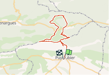

Length
18 km

Max alt
998 m

Uphill gradient
973 m
Km-Effort
31 km

Min alt
333 m

Downhill gradient
988 m
Boucle
Yes
Creation date :
2024-10-30 07:22:34.0
Updated on :
2024-10-30 15:37:30.082

FREE GPS app for hiking
 SityTrail
IGN / Geographical institutes
SityTrail Plus
The world is yours!
About
Trail of 18 km to be discovered at Provence-Alpes-Côte d'Azur, Bouches-du-Rhône, Puyloubier. This trail is proposed by GeorgesV..
Positioning
Country:
France
Region :
Provence-Alpes-Côte d'Azur
Department/Province :
Bouches-du-Rhône
Municipality :
Puyloubier
Location:
Unknown
Start:(Dec)
Start:(UTM)
716100 ; 4822594 (31T) N.
Comments