


Mont Caume

ARPF1
User
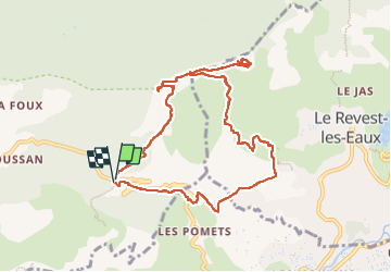

Length
11.1 km

Max alt
788 m

Uphill gradient
597 m
Km-Effort
19.1 km

Min alt
236 m

Downhill gradient
605 m
Boucle
Yes
Creation date :
2024-10-29 08:48:21.017
Updated on :
2024-11-06 10:22:41.954
4h19
Difficulty : Very difficult

FREE GPS app for hiking
 SityTrail
IGN / Geographical institutes
SityTrail Plus
The world is yours!
About
Trail Walking of 11.1 km to be discovered at Provence-Alpes-Côte d'Azur, Var, Évenos. This trail is proposed by ARPF1.
Positioning
Country:
France
Region :
Provence-Alpes-Côte d'Azur
Department/Province :
Var
Municipality :
Évenos
Location:
Unknown
Start:(Dec)
Start:(UTM)
734756 ; 4783842 (31T) N.
Comments