


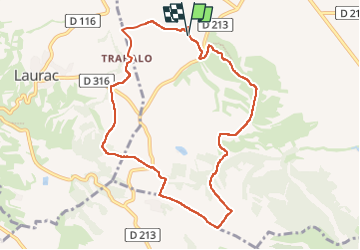
Boucle du Besplas

caccini
User

Length
9.8 km

Max alt
318 m

Uphill gradient
216 m
Km-Effort
12.7 km

Min alt
206 m

Downhill gradient
219 m
Boucle
Yes
Creation date :
2024-10-31 07:46:57.104
Updated on :
2024-10-31 16:10:04.214
2h52
Difficulty : Easy
2h52
Difficulty : Difficult

FREE GPS app for hiking
 SityTrail
IGN / Geographical institutes
SityTrail Plus
The world is yours!
About
Trail On foot of 9.8 km to be discovered at Occitania, Aude, Villasavary. This trail is proposed by caccini.
Description
La Boucle de Besplas est de difficulté moyenne. Elle chemine à travers les prairies et les bois communaux, aux alentours des villages de Villasavary et Laurac.
Positioning
Country:
France
Region :
Occitania
Department/Province :
Aude
Municipality :
Villasavary
Location:
Unknown
Start:(Dec)
Start:(UTM)
418916 ; 4787171 (31T) N.
Comments