


SityTrail - 4241661 - 20241031-saintxmathurin-nord-xemax-pour-tuiles

Doubotis
User ADMIN
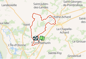

Length
28 km

Max alt
71 m

Uphill gradient
223 m
Km-Effort
31 km

Min alt
4 m

Downhill gradient
224 m
Boucle
Yes
Creation date :
2024-10-31 11:27:10.681
Updated on :
2024-11-12 08:32:19.369
7h00
Difficulty : Medium

FREE GPS app for hiking
 SityTrail
IGN / Geographical institutes
SityTrail Plus
The world is yours!
About
Trail On foot of 28 km to be discovered at Pays de la Loire, Vendée, Saint-Mathurin. This trail is proposed by Doubotis.
Positioning
Country:
France
Region :
Pays de la Loire
Department/Province :
Vendée
Municipality :
Saint-Mathurin
Location:
Unknown
Start:(Dec)
Start:(UTM)
598161 ; 5157525 (30T) N.
Comments