


chaude fontaine

dcharbonnier
User
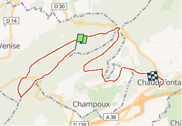

Length
10.1 km

Max alt
516 m

Uphill gradient
189 m
Km-Effort
13.4 km

Min alt
282 m

Downhill gradient
408 m
Boucle
No
Creation date :
2024-10-31 09:49:11.62
Updated on :
2024-10-31 13:57:54.426
4h07
Difficulty : Difficult

FREE GPS app for hiking
 SityTrail
IGN / Geographical institutes
SityTrail Plus
The world is yours!
About
Trail Walking of 10.1 km to be discovered at Bourgogne-Franche-Comté, Doubs, Venise. This trail is proposed by dcharbonnier.
Positioning
Country:
France
Region :
Bourgogne-Franche-Comté
Department/Province :
Doubs
Municipality :
Venise
Location:
Unknown
Start:(Dec)
Start:(UTM)
283311 ; 5247799 (32T) N.
Comments