


Pic Leviste

chasle
User
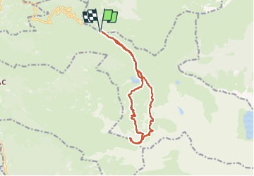

Length
15 km

Max alt
2434 m

Uphill gradient
982 m
Km-Effort
28 km

Min alt
1558 m

Downhill gradient
980 m
Boucle
Yes
Creation date :
2024-10-31 07:39:54.076
Updated on :
2024-10-31 17:55:37.468
4h58
Difficulty : Difficult

FREE GPS app for hiking
 SityTrail
IGN / Geographical institutes
SityTrail Plus
The world is yours!
About
Trail Walking of 15 km to be discovered at Occitania, Hautespyrenees, Beaucens. This trail is proposed by chasle.
Positioning
Country:
France
Region :
Occitania
Department/Province :
Hautespyrenees
Municipality :
Beaucens
Location:
Unknown
Start:(Dec)
Start:(UTM)
255861 ; 4761671 (31T) N.
Comments