


Retour

ophness
User

Length
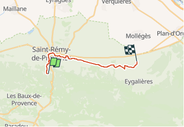
14.7 km

Max alt
172 m

Uphill gradient
93 m
Km-Effort
16.2 km

Min alt
59 m

Downhill gradient
179 m
Boucle
No
Creation date :
2024-11-01 14:12:20.0
Updated on :
2024-11-01 14:12:30.827

FREE GPS app for hiking
 SityTrail
IGN / Geographical institutes
SityTrail Plus
The world is yours!
About
Trail of 14.7 km to be discovered at Provence-Alpes-Côte d'Azur, Bouches-du-Rhône, Saint-Rémy-de-Provence. This trail is proposed by ophness.
Positioning
Country:
France
Region :
Provence-Alpes-Côte d'Azur
Department/Province :
Bouches-du-Rhône
Municipality :
Saint-Rémy-de-Provence
Location:
Unknown
Start:(Dec)
Start:(UTM)
647085 ; 4847815 (31T) N.
Comments