


Ardèche j1

cmike39
User
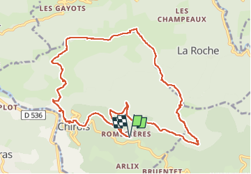

Length
12.5 km

Max alt
982 m

Uphill gradient
704 m
Km-Effort
22 km

Min alt
351 m

Downhill gradient
702 m
Boucle
Yes
Creation date :
2024-11-01 11:59:09.033
Updated on :
2024-11-01 16:15:21.313
4h15
Difficulty : Very difficult

FREE GPS app for hiking
 SityTrail
IGN / Geographical institutes
SityTrail Plus
The world is yours!
About
Trail Walking of 12.5 km to be discovered at Auvergne-Rhône-Alpes, Ardèche, Chirols. This trail is proposed by cmike39.
Positioning
Country:
France
Region :
Auvergne-Rhône-Alpes
Department/Province :
Ardèche
Municipality :
Chirols
Location:
Unknown
Start:(Dec)
Start:(UTM)
603128 ; 4948579 (31T) N.
Comments