


SJDC 2025: CONQUES - MOISSAC

djeepee74
User
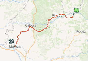

Length
216 km

Max alt
638 m

Uphill gradient
4725 m
Km-Effort
280 km

Min alt
72 m

Downhill gradient
4951 m
Boucle
No
Creation date :
2024-11-01 20:25:07.153
Updated on :
2025-05-22 17:36:22.472
63h39
Difficulty : Very difficult

FREE GPS app for hiking
 SityTrail
IGN / Geographical institutes
SityTrail Plus
The world is yours!
About
Trail Walking of 216 km to be discovered at Occitania, Aveyron, Conques-en-Rouergue. This trail is proposed by djeepee74.
Description
Ce tracé ne rentre pas dans Cahors.
Points of interest

Positioning
Country:
France
Region :
Occitania
Department/Province :
Aveyron
Municipality :
Conques-en-Rouergue
Location:
Unknown
Start:(Dec)
Start:(UTM)
452108 ; 4938666 (31T) N.
Comments