


salavas_salavas_48km_680_d-12060547-1730538143-509

topolino
User
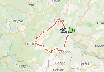

Length
49 km

Max alt
372 m

Uphill gradient
768 m
Km-Effort
59 km

Min alt
79 m

Downhill gradient
768 m
Boucle
Yes
Creation date :
2024-11-02 09:07:03.705
Updated on :
2024-11-02 09:07:03.705
--
Difficulty : Very difficult

FREE GPS app for hiking
 SityTrail
IGN / Geographical institutes
SityTrail Plus
The world is yours!
About
Trail Bicycle tourism of 49 km to be discovered at Auvergne-Rhône-Alpes, Ardèche, Salavas. This trail is proposed by topolino.
Positioning
Country:
France
Region :
Auvergne-Rhône-Alpes
Department/Province :
Ardèche
Municipality :
Salavas
Location:
Unknown
Start:(Dec)
Start:(UTM)
610154 ; 4916844 (31T) N.
Comments