


babapu

Liebeaux
User
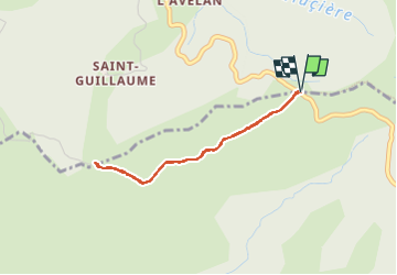

Length
3.2 km

Max alt
414 m

Uphill gradient
44 m
Km-Effort
3.8 km

Min alt
377 m

Downhill gradient
45 m
Boucle
Yes
Creation date :
2024-11-02 10:22:04.976
Updated on :
2024-11-02 11:52:03.82
1h29
Difficulty : Easy

FREE GPS app for hiking
 SityTrail
IGN / Geographical institutes
SityTrail Plus
The world is yours!
About
Trail Walking of 3.2 km to be discovered at Provence-Alpes-Côte d'Azur, Var, Collobrières. This trail is proposed by Liebeaux.
Positioning
Country:
France
Region :
Provence-Alpes-Côte d'Azur
Department/Province :
Var
Municipality :
Collobrières
Location:
Unknown
Start:(Dec)
Start:(UTM)
281023 ; 4787023 (32T) N.
Comments