


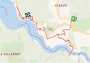
passerelle du montenard en A/R

scalpy
User

Length
5.9 km

Max alt
644 m

Uphill gradient
153 m
Km-Effort
8.4 km

Min alt
470 m

Downhill gradient
294 m
Boucle
No
Creation date :
2024-11-02 10:13:25.17
Updated on :
2024-11-02 12:11:31.742
1h35
Difficulty : Easy

FREE GPS app for hiking
 SityTrail
IGN / Geographical institutes
SityTrail Plus
The world is yours!
About
Trail Walking of 5.9 km to be discovered at Auvergne-Rhône-Alpes, Isère, Mayres-Savel. This trail is proposed by scalpy.
Description
petite balade sans prendre le bateau donc sans faire la vraie grande boucle
Positioning
Country:
France
Region :
Auvergne-Rhône-Alpes
Department/Province :
Isère
Municipality :
Mayres-Savel
Location:
Unknown
Start:(Dec)
Start:(UTM)
713933 ; 4972685 (31T) N.
Comments