


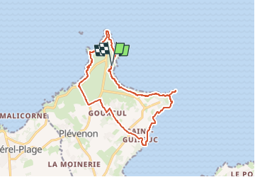
Cap Fréhel et fort de la Latte

geoffrayLayeux
User

Length
14.6 km

Max alt
77 m

Uphill gradient
273 m
Km-Effort
18.2 km

Min alt
5 m

Downhill gradient
272 m
Boucle
Yes
Creation date :
2024-11-02 13:07:04.639
Updated on :
2024-11-02 13:08:05.003
4h08
Difficulty : Difficult

FREE GPS app for hiking
 SityTrail
IGN / Geographical institutes
SityTrail Plus
The world is yours!
About
Trail Walking of 14.6 km to be discovered at Brittany, Côtes-d'Armor, Plévenon. This trail is proposed by geoffrayLayeux.
Positioning
Country:
France
Region :
Brittany
Department/Province :
Côtes-d'Armor
Municipality :
Plévenon
Location:
Unknown
Start:(Dec)
Start:(UTM)
550410 ; 5391744 (30U) N.
Comments