


xxxx

cmike39
User
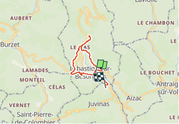

Length
10.7 km

Max alt
894 m

Uphill gradient
442 m
Km-Effort
16.6 km

Min alt
610 m

Downhill gradient
456 m
Boucle
No
Creation date :
2024-11-02 09:07:37.583
Updated on :
2024-11-02 13:44:21.999
4h35
Difficulty : Difficult

FREE GPS app for hiking
 SityTrail
IGN / Geographical institutes
SityTrail Plus
The world is yours!
About
Trail Walking of 10.7 km to be discovered at Auvergne-Rhône-Alpes, Ardèche, Labastide-sur-Bésorgues. This trail is proposed by cmike39.
Positioning
Country:
France
Region :
Auvergne-Rhône-Alpes
Department/Province :
Ardèche
Municipality :
Labastide-sur-Bésorgues
Location:
Unknown
Start:(Dec)
Start:(UTM)
603220 ; 4953206 (31T) N.
Comments