


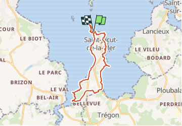
Autour de Saint-Jacut-de-la-Mer

geoffrayLayeux
User

Length
12.8 km

Max alt
41 m

Uphill gradient
148 m
Km-Effort
14.7 km

Min alt
-2 m

Downhill gradient
148 m
Boucle
Yes
Creation date :
2024-11-02 13:55:32.926
Updated on :
2024-11-02 13:56:11.057
3h21
Difficulty : Difficult

FREE GPS app for hiking
 SityTrail
IGN / Geographical institutes
SityTrail Plus
The world is yours!
About
Trail Walking of 12.8 km to be discovered at Brittany, Côtes-d'Armor, Saint-Jacut-de-la-Mer. This trail is proposed by geoffrayLayeux.
Positioning
Country:
France
Region :
Brittany
Department/Province :
Côtes-d'Armor
Municipality :
Saint-Jacut-de-la-Mer
Location:
Unknown
Start:(Dec)
Start:(UTM)
559514 ; 5384099 (30U) N.
Comments