


La Cotentin

geoffrayLayeux
User
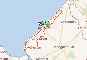

Length
15.3 km

Max alt
92 m

Uphill gradient
310 m
Km-Effort
19.5 km

Min alt
10 m

Downhill gradient
310 m
Boucle
Yes
Creation date :
2024-11-02 15:28:34.587
Updated on :
2024-11-02 15:29:11.814
4h25
Difficulty : Very difficult

FREE GPS app for hiking
 SityTrail
IGN / Geographical institutes
SityTrail Plus
The world is yours!
About
Trail Walking of 15.3 km to be discovered at Brittany, Côtes-d'Armor, Lamballe-Armor. This trail is proposed by geoffrayLayeux.
Positioning
Country:
France
Region :
Brittany
Department/Province :
Côtes-d'Armor
Municipality :
Lamballe-Armor
Location:
Planguenoual
Start:(Dec)
Start:(UTM)
529148 ; 5377587 (30U) N.
Comments