


Ardèche j2

cmike39
User
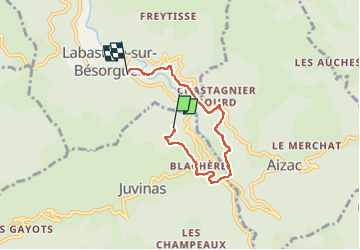

Length
5 km

Max alt
667 m

Uphill gradient
209 m
Km-Effort
7.7 km

Min alt
498 m

Downhill gradient
201 m
Boucle
No
Creation date :
2024-11-02 13:44:38.158
Updated on :
2024-11-02 15:52:25.902
2h07
Difficulty : Medium

FREE GPS app for hiking
 SityTrail
IGN / Geographical institutes
SityTrail Plus
The world is yours!
About
Trail Walking of 5 km to be discovered at Auvergne-Rhône-Alpes, Ardèche, Juvinas. This trail is proposed by cmike39.
Positioning
Country:
France
Region :
Auvergne-Rhône-Alpes
Department/Province :
Ardèche
Municipality :
Juvinas
Location:
Unknown
Start:(Dec)
Start:(UTM)
603848 ; 4952500 (31T) N.
Comments