


die sagatte

veroarvinberod
User
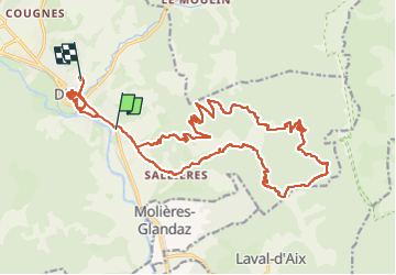

Length
29 km

Max alt
1071 m

Uphill gradient
1166 m
Km-Effort
44 km

Min alt
400 m

Downhill gradient
1108 m
Boucle
No
Creation date :
2024-11-02 10:03:18.845
Updated on :
2024-11-02 20:55:55.929
10h51
Difficulty : Very difficult

FREE GPS app for hiking
 SityTrail
IGN / Geographical institutes
SityTrail Plus
The world is yours!
About
Trail Mountain bike of 29 km to be discovered at Auvergne-Rhône-Alpes, Drôme, Die. This trail is proposed by veroarvinberod.
Positioning
Country:
France
Region :
Auvergne-Rhône-Alpes
Department/Province :
Drôme
Municipality :
Die
Location:
Unknown
Start:(Dec)
Start:(UTM)
688820 ; 4957449 (31T) N.
Comments