


Luxembourg 03/11/24

Isabelle1969
User
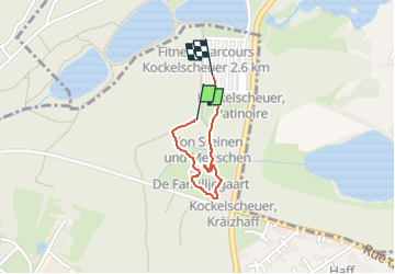

Length
840 m

Max alt
313 m

Uphill gradient
7 m
Km-Effort
946 m

Min alt
301 m

Downhill gradient
11 m
Boucle
Yes
Creation date :
2024-11-03 08:36:52.796
Updated on :
2024-11-03 09:13:11.799
35m
Difficulty : Very easy

FREE GPS app for hiking
 SityTrail
IGN / Geographical institutes
SityTrail Plus
The world is yours!
About
Trail Walking of 840 m to be discovered at Unknown, Canton Esch-sur-Alzette, Roeser. This trail is proposed by Isabelle1969.
Positioning
Country:
Luxembourg
Region :
Unknown
Department/Province :
Canton Esch-sur-Alzette
Municipality :
Roeser
Location:
Unknown
Start:(Dec)
Start:(UTM)
290788 ; 5494218 (32U) N.
Comments