


port Bourgenay

taguette
User
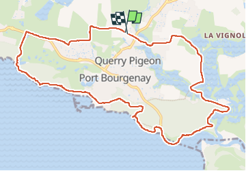

Length
12.7 km

Max alt
28 m

Uphill gradient
102 m
Km-Effort
14 km

Min alt
0 m

Downhill gradient
101 m
Boucle
Yes
Creation date :
2024-11-03 07:09:25.028
Updated on :
2024-11-03 09:32:15.993
2h22
Difficulty : Difficult

FREE GPS app for hiking
 SityTrail
IGN / Geographical institutes
SityTrail Plus
The world is yours!
About
Trail Walking of 12.7 km to be discovered at Pays de la Loire, Vendée, Talmont-Saint-Hilaire. This trail is proposed by taguette.
Positioning
Country:
France
Region :
Pays de la Loire
Department/Province :
Vendée
Municipality :
Talmont-Saint-Hilaire
Location:
Unknown
Start:(Dec)
Start:(UTM)
602320 ; 5145103 (30T) N.
Comments