


Retour j3

ophness
User
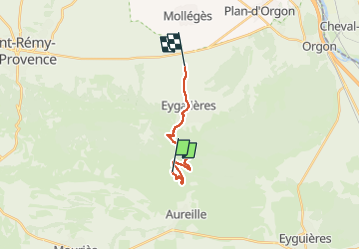

Length
12.6 km

Max alt
332 m

Uphill gradient
149 m
Km-Effort
15.5 km

Min alt
60 m

Downhill gradient
416 m
Boucle
No
Creation date :
2024-11-03 10:24:27.0
Updated on :
2024-11-03 10:24:29.281

FREE GPS app for hiking
 SityTrail
IGN / Geographical institutes
SityTrail Plus
The world is yours!
About
Trail of 12.6 km to be discovered at Provence-Alpes-Côte d'Azur, Bouches-du-Rhône, Aureille. This trail is proposed by ophness.
Positioning
Country:
France
Region :
Provence-Alpes-Côte d'Azur
Department/Province :
Bouches-du-Rhône
Municipality :
Aureille
Location:
Unknown
Start:(Dec)
Start:(UTM)
656147 ; 4843537 (31T) N.
Comments